nakedeyeview.com.my 2008


page 1
INTRODUCTION THE "SILK ROUTE" TOUR OF XINJIANG The ancient silk routes in Xinjiang, China had all been replaced with motorways and railways, but there are still fascinating relics left in their wake. My family and I spent three weeks exploring the region by road, train and air, but could only cover less than half of what the region could offer to travellers like us. But some of the spectacular places we visited were so remote and difficult (sometimes hazardous) to access that they were not even mentioned in tourist brochures. Read on to find out more about our adventures along the "silk routes" and what Xinjiang has to offer… |
The ancient silk routes
 A short history of the routes
When one thinks of the ancient silk routes one would invariably conjure up images of caravans of camels, loaded with silk and satins, and merchants trekking through searing deserts, boundless and barren. Without doubt, that was exactly how early trade in silk and other merchandise was carried out against many incredible odds along these arduous routes some 2000 years ago.
The ancient trade route started from Chang'an (present day X'ian), the ancient capital of China during the Han Dynasty in the second century BC. It linked China and Europe through Central and Western Asia covering a distance of over 10,000 kilometers. The name "Silk Road" was used by a German geographer only in 1870s to describe the great East-West trade route.
The trade along these routes flourished and waned for over a thousand years in tandem with the rise and fall of the Chinese dynasties. This was because political developments had enormous influence on trade along the routes as only strong and stable governments could foster trade.
Trade declined during the fall of the Han Dynasty in the 3rd century and revived again during the rise of the Tang Dynasty in the 7th century. The fall of the Tang Dynasty in the early 10th century again saw the decline of trade along the silk routes. But it revived again under the Sung Dynasty in the eleventh and twelfth centuries. The trade along the routes saw its heydays in the 13th century when the conquest of the Mongols ushered in a new era of contacts between the East and the West. It was during this time that Marco Polo made the trip along the silk-road from China to Europe.
As the overland trade along the silk routes prospered, it became increasingly more dangerous and unprofitable due to looters and raiders, bribery and corruption. The discovery of the alternative sea route around the Cape of Good Hope in the 15th century finally tolled the death knell of trade along the silk routes. It has been quite remarkable that the silk-road trade could survive for over a thousand years in spite of the expense, inhospitalities and dangers of the routes.
The goods traded along the silk-road had to be low in volume and high in value because only limited amount of the goods could be carried by each camel. Therefore the trade was confined to only luxury items which brought only limited economic benefits to the governments. However, the silk-road trade did help to develop oases and small towns along the routes, which provided the merchants and animals with supplies of food and water.
Though the silk-road trade had limited economic contribution, its social and cultural impacts were significant. The trade route provided communication and contacts between the Chinese and other foreign merchants of different religions and cultures. It was through this trade route that Buddhism was introduced to China from India.
The Silk Road in Xinjiang, China

In Xinjiang Uygur Autonomous Region, there were three principal routes that the ancient Silk Road followed. These were the Southern, Central and Northern Route which developed at different times in response to changing political circumstances and environmental consideration. They were all arduous and dangerous but traversed through some of the most spectacular and awe-inspiring scenery on earth.
Though these routes have been replaced by modern means of transport, they left fascinating relics in their wake. Some of the outposts and sites along the routes had been reduced to ruins but others like Turpan and Kashi have prospered and become important commercial and tourist destinations in Xinjiang.
The present main road system in Xinjiang going from east to west also follows quite closely routes of the ancient Silk Road.
The earliest silk route through Xinjiang was the southern route. The present route starts from Dunhuang in Gansu Province and goes southwesterly direction and threads across Altun Mountains and barren deserts to Ruoqiang. From here the route skirts along the northern slopes of Kunlun Mountains and through the vast and barren Taklimakan Desert to reach Hotan, an oasis town famous for its jades. The route continues its journey along the foot of kunlun and the Pamirs mountain range to reach Kashi (Kashgar), the famous western-most city of China.
It has been reported that this route is not in very good condition, particularly the initial section from Dunhuang to Ruoqiang. To circumvent this, there is now a road across the Taklimakan desert from Korla, an oasis town along the central route, to Ruoqiang.
The central route, also known as the olden northern route, also starts from Dunhuang, but goes northwesterly direction to Hami, the eastern gate to Xinjiang. From here, the route follows the foothills of Tian-shan and skirts the northern rim of the Taklimakan Desert. It passes the rich oasis towns of Turpan, Korla, Kuqa, Aksu and finally meeting the southern route at Kashi.
 From Kashi, travelers can travel westward and cross the border to enter the present-day Kirghizstan, Uzbekstan and Tadzhikistan. Also travelers can continue southward and cross the high Pamirs to Kaxkorgan, the gateway to Pakistan and Afghanistan.
The present-day northern route starts from Hami and from here one can travel westward along the northern side of the Tian-shan Mountains to Mori. Then it skirts the Gurbantunggut Desert in the Jungar Basin to Quitai, Jimsar and the capital city of Urumuqi. Continue from here the route goes westward to Kuytun, passes by the scenic Karim Lake and arrive at Korgas border check-point, the entrance to Kazakhstan.
All the three routes are long and many sections are in very poor conditions. They all either traverse across mountains or pass through wide expanse of grasslands and barren deserts with sparse inhabitants. It is therefore advisable that travelers should use jeeps or 4WD vehicles and better travel in more than one vehicle so as to help each other when one faces problem along the way.
Initial Travel Plan
The tour was originally planned to depart from KLIA on 30/8/00. The others on this tour, besides my wife Lucy and son Ming, were MP Chin, his wife and another friend. The itinerary was drawn up in such a manner so that Ming would return after two weeks; Chin, his wife and friend after three weeks and my wife & I after four weeks. Basically we would be in Xinjiang for two weeks, Gansu (Dunhuang) one week and Shanxi (Xian) one week. A quotation based on the above itinerary was obtained from a Chinese Tour Agency based in Xian University (www.travelchinaguide.com).
However, the above plan had to be aborted because Malaysian Airlines could not confirm all our out-bound flights and Mrs. Chin had to apply for her vacation leave which required a 3 week notice. With the withdrawal of three persons, the tour agency in China tried to hike up the fees and I had no choice but to reject them.
Finally we were left to our own resources and managed, by pulling a cable through a friend, to get our out-bound flights confirmed on 6/9/00.
As we would be arriving in Urumqi near midnight on 6/9/00, accommodation might pose a problem if we did not have any hotel reservation. Therefore, prior to departure I contacted www.sinohotel.com and through them we had a hotel reservation in Hotel World Plaza in Urumqi on the date of our arrival. At the same time and while browsing in the Net (www.bootsnall.com), Ming came across an article by Jim He-liang on Xinjiang and Urumqi. Jim seemed to know the country well and it would be useful for us to gather some information from him. I therefore contacted Jim by email and arranged to meet at the hotel after our arrival. (When I came home, I discovered that Jim's article in bootsnall.com was copied verbatim from one published in "China Tourism".)
Tour Itinerary
Introduction
Jim came to the hotel after midnight to meet me. He was a young man of 28, now working in a musical instrument shop selling guitars. He had worked as a tourist guide before.
I told him about our travel plans in Xinjiang and gave him a copy of the itinerary from 08 to 20 Sept, which I prepared previously. He agreed to get a quotation from his previous company for a 4WD vehicle with an experienced driver for this period. At the same time I agreed to his proposal to be our tour-guide for two days i.e. 8 & 9 of Sept to visit Tian-chi (Heavenly Lake) and Nan-shan (Southern Mountains) for 600 yuans (RM280 @ RM0.47 = 1 yuan) a day inclusive of the cost of hiring a car/taxi.
While we chose to explore Urumqi City on our own the next day (07 Sept) I had not decided yet on the itinerary for the rest of our journey from 21 to 27 Sept after Ming's return to Malaysia on 21 Sept.
Part One of Itinerary-In & Around Urumqi
Part One of our itinerary is from date of arrival in Urumqi on 06/09/00 to 09/09/00. During these few days we made Urumqi our base.
Sep 06 : KLIA to Beijing to Urumqi
We arrived at Urumqi airport at about 11.00 pm. We took a tourist coach from Urumqi airport to Hotel World Plaza for 10 yuan each. On the way, the tour operator tried to book us on their organised tours for the next couple of days.
I met Jim at the hotel. I was informed that only International hotels (4 & 5-star) accept credit cards and most other outlets including restaurants and tour companies accept only cash!
Sept 07: Urumqi
I was awake at about 8.00am and it was still dark outside. Note: Xinjiang Time, used to be 2 hours behind Beijing Time, but is now the same as Beijing Time and therefore there is no time difference between Malaysia and Xinjiang. Based on the geographical location of Urumqi, Xinjiang Time should actually be two hours behind Beijing Time. Though Beijing Time has been adopted throughout Xinjiang, appointments are still made with specified Xinjiang or Beijing Time. The normal office hours in Xinjiang are from 10.00am to 7.00pm (Beijing Time).
Urumqi is not only the capital but also the political, economic and cultural centre of Xinjiang Uygur Autonomous Region. In Mongolian Urumqi means "beautiful pastures". In ancient times, the area where the city lies was a fertile grassland with plenty of water and inhabited by various ethnic nomadic tribes.
 |
| a mobile lavatory in Urumqi |
The city is located at an elevation of about 900 meters above sea level on the northern side of the Tian-shan Mountains. It has a population of about 1,500,000 consisting of 36 different nationalities including Han, Uygur, Hui, Kazak, Mongol and Russians. Of the total population, over 70% are Han nationality, 10% Uygur and 10% Hui and the remainder other minority nationalities. It is the only city / town in Xinjiang where Hans form the majority of the population. Over the years each nationality has managed to preserve its tradition and characteristics and as a result, Urumqi becomes a multinational city with all nationalities living side by side giving it a very unique appearance.
I had local breakfast in an open market opposite the hotel. Armed with a city map, we tried to walk to Hong-shan (Red Mountain) park in the city centre. After a while we realised it was too long a distance to walk and so we took a taxi instead.
Earlier, we went to the Bank of China near the hotel to inquire about withdrawing cash using ATM and credit cards. I found out that the ATM machines in Xinjiang (not many around) were for the use of customers issued with their bank's cards, and only one branch of the Bank in Urumqi would accept credit cards for cash withdrawal. I therefore asked for the address of this branch, which was near Hong-shan.
 |
Hong-shan Park
|
Hong-shan Park is the landmark of Urumqi and is situated in the centre of the city. It is over 900 meters above sea level. There is a pagoda, a pavilion and a temple on top of the hill, from there it offers a panoramic view of the city with all its tall and modern buildings on one side and the snow-capped Tian-shan Mountains on the opposite side. It is a pleasant spot for a stroll.
Coming down the Hong-shan, we strolled around the streets in the centre of Urumqi. At lunchtime we went to a food court and were surprised to see a stall selling Roti-Canai from Malaysia!
After lunch, we asked for the direction to the bank where I hoped to withdraw some cash with my credit card. We walked and arrived there to find that the branch was small and quite deserted. I ran into trouble with the bank as they would not accept my credit card!
After the bank, we took a taxi to Xinjiang Museum. The Museum is well stocked with ancient Xinjiang historical and cultural relics, the highlights of which are the ancient corpses. Due to Xinjiang's dry climatic conditions, the relics are well preserved. The oldest corpse on display is an over 3000 year-old and well-preserved female dug up in Loulan. It has long hair, a shapely figure and a beauty face with Caucasian complexion. It is known as "Loulan beauty". Incidentally, the best red wine of Xinjiang also comes from Loulan and is called "Loulan Gan Hong".
Coming out of the Museum, we strolled around the smaller streets of the city. In one of the side lanes, we saw a cart loaded with Hemi melons. We bought a 3-4 kg melon for only one yuan! We had a nice, crispy and sweet melon as our 'evening tea' in our hotel room.
Sept 08: Urumqi to Tian-chi Lake
Jim came to the hotel with a taxi at 9.30 am to take us to the Heavenly Lake, about 100 km north-east of Urumqi. A highway from Urumqi leads to Fukang and from there a mountainous road winds its way up the Tian-shan Mountains. The road passes through the Stone Gate Pass before it reaches the Heavenly Lake. Along the way to the lake, there are round mushroom-top yurt huts owned by Kazaks, the nomadic herders who live on the grasslands of Xinjiang. Some of these yurts also serve as inns and restaurants.
 |
Tian-chi Lake (Heavenly Lake)
|
The mountaintop Tian-chi Lake is about 5 sq. km in area and is at nearly 2000 meters above sea level. The lake, surrounded by snow-capped mountains, is peaceful and scenic, though not spectacular at the time of our visit. Visitors can have boat rides in the lake and take strolls or ride horses along paths that lead to waterfalls, temples and other scenic spots around the lake.
We went to a restaurant near the lake to have lunch. Their special dish was supposed to be the fish from Tian-chi. Before ordering I asked the waiter about the size of the fish. Using his two forefingers, he indicated the length to be about 6-8 inches. Amongst other dishes, I ordered 4 deep-fried Tian-chi fish for the four of us (including Jim) and the price was 8 yuans each, comparatively expensive. When the dish was served, we were all surprised to see that the fish was no bigger than 2 inches, from head to tail! Adding salt to injury, the waiter had the cheek to tell us that for the same price he had given us five fish instead of four!
Jim volunteered to take us for dinner that night. We went to the night market at Wuyi (May 1st ) Street near the city centre and just in front of Hong-fu Hotel (4-star). The whole street was well lit with both sides lined with stalls selling all sorts of exotic and mouth-watering Xinjiang foods. There were "nan", the hard local bread, lamb shish kebab (like our satay but served without peanut sauce), "pulao" or "finger rice" to the Han people, roast whole lamb and many other local snacks, delicacies and fruits.
"Nan", baked in a "nan" pit, is the staple food of the Uygur people and is made of wheat flour. They are round and of various sizes.
I had some lamb shish kebab and beef noodles while reserving roast whole lamb for the next time.
After dinner, Jim took us to his parents' flat nearby to meet his father. It was a four-storey apartment with 2 bedrooms, very basically furnished with a TV and a fridge. We met his father who retired a couple of years ago and had traveled quite extensively in Xinjiang. We talked and ate watermelon.
Sept 09: Urumqi to Nan-shan (Southern Mountains) Pasture
In the morning we went with Jim to Nan-shan Pasture, a scenic area about 75 km south of Urumqi on the northern slopes of the Tian-shan Mountains.
 |
Wildlife Abuse |
On the way, we stopped at the Urumqi Zoo to see the giant Xinjiang bears and the Xinjiang Snow leopards. The Zoo area was big but sparsely stocked and badly maintained. There were two white giant adult bears kept in a large cage, but a baby bear was kept outside with a leash tied through its nostrils! This was to allow visitors who had to pay a fee to take photographs. Never mind about cruelty to animals, I nevertheless took a picture of the baby bear but refused to pay, and was instantly shooed away by its keeper. There were a couple of leopards kept in cages at another section of the zoo. They were quite similar to those I saw in Tanzanian safaris.
Moving away from the city, the journey became more pleasant as it wound through lush pastures, hills and valleys. Xibaiyang (west poplar) Gully is a vast picturesque meadow dotted with herds of cattle and Kazak yurt huts. The Gully also teemed with bee-farms and there were many beekeepers selling their honey on the roadsides.
The journey by vehicles ended when we arrived at the Baiyang (poplar) River up in the mountains. This is a base where if one wants to proceed further up to the waterfall (about 3 km away) one can either pay to ride a horse or ride on a horse cart. But one can also go up by foot but the journey would not pleasant because the road is badly maintained and is full of slime and animal droppings. We trekked up this road which took us more than an hour, but were disappointed when we reached the waterfall because it was nothing really spectacular considering the trouble we went through.
Returning to the base, we had lunch in one of the Kazak yurt huts, which served as a restaurant. We had traditional Kazak milk tea, shish kebab, pulao and noodles. To me, the food was good but Lucy and Ming had stomach upset during the night!
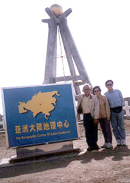 |
At the Center of the Asian Continent
|
On the way back to Urumqi, and about 25 km from the city the driver took us, through a 9 km of unpaved farm road, to the "Center of Asian Continent". It is simple 4-leg concrete "tripod" hanging a metal plumbline indicating the location of the geographical centre of the Asian Continent. It is supposed to be at a Latitude of 43* 41' north and Longitude 87* 20' east and this location was established and approved by authorities in Xinjiang in 1992. It was quite an isolated place and we hardly saw any tourists there.
Journey by 4WD from 10 Sept to 20 Sept
Jim had earlier given me a quotation from Xinjiang Kanas International Travel Service (Kanas). I agreed to the quotation of hiring a 4WD vehicle with a driver for 800 yuan per day which included all expenses relating to running and maintenance of the vehicle, toll charges and living expenses of the driver. I fully settled the amount in US$ and signed a contract. The tour was in accordance with the itinerary I provided and would end in Urumqi on 20 Sept. The places covered were: Korla, Koqa, Bayanbulak, Tulufan and Jimsar.
Sept 10: Urumqi to Korla
At 9.30 am Jim and the boss of Kanas, Mr. Mark Zhong came to meet me at the hotel. I had a brief discussion with Mark and told him that my wife and I had decided to spend the rest of our sojourn (21 to 28 Sept) in Kashi, the western most city of Xinjiang. I asked him to prepare an itinerary for this sector of the journey and told him that I preferred to travel by train for the return journey from Urumqi to Kashi.
The driver (Mr. Wu, Goh in Hokkien) was a Han Chinese of about 50. He claimed to have traveled to all parts of Xinjiang though he admitted that he had been to some of the places in my itinerary only once and that was many years ago. I told him that I had an International driving licence and that I could take over the wheel whenever he felt tired. But he was not impressed. I tried not to talk too much to him in the vehicle because he had a terrible bad-breath.
The vehicle was a Toyota Land Cruiser. Wu told me it was only 3 years old but it looked to me that it was very much overused for a vehicle of that age. We loaded our luggage at the back of the vehicle with Lucy and Ming sitting behind and I beside Wu.
Korla is about 450 km south of Urumqi. It takes about 6 hours non-stop by the highway, which passes through Toksun, a town not far from Tulufan, Kumux, Bosten Lake and Yanqi.
 |
Dabancheng Wind Power Station
|
There were some beautiful scenery along the way. Not far after leaving Urumqi, we passed by a place called Dabancheng Wind Power Station, claimed to be the largest of its kind in Asia with a current total generating capacity of nearly 60,000 kilowatts. There were about 100 of these generators each consisting of a tower mast 50 meters high with a propeller at the top. As wind is a natural resource, the generators produce low-cost power and are environmentally friendly. It is estimated that this area has a production capacity of 2,500,000 kilowatts.
A major part of the road crossed mountains and valleys and there were many scenic spots particularly along the mountainous road approaching Korla. This road was a new two-lane road constructed without any passing lane. So all vehicles would travel in a single file and normally the traffic swould be led by the slowest of the crawling trucks. Perhaps it was meant to be this way so that all would have to go slowly to enjoy the beautiful scenery of the mountain passes.
The road to Korla was generally good. However, our journey was an eventful one. A stretch of the road not far from Toksun was under repair and was closed to all traffic. However, there was no road sign to warn motorists of the closure until reaching the roadblock (a typical road repair in Xinjiang). By then one would have missed the temporary bypass and had to turn back a couple of km to get into it. Wu was the one who missed the bypass and decided to take a short cut to join it. Unfortunately one of the back wheels got stuck in an earth drain and the vehicle was immobilised. Luckily another 4WD passed by and using a steel cable our vehicle was pulled out of the drain.
That was not all. Half way to Korla, Wu suspected that there was something wrong with one of the front wheels. He stopped and inspected it and found that lubricant was leaking from the wheel's hub. We carried on rather slowly to the next town and Wu found a small motor workshop to replace that gasket. The repair took nearly two hours and I spent most of the time sitting outside a nearby Muslim restaurant run by a Hui, drinking beer, eating garlic and talking to the restaurant owner.
By the time we reached Korla it was already evening. We went to Bosten Hotel but found it not too clean. Next we went to Bayinguoleng Hotel and found that it had no more vacancy. We finally settled in Loulan Hotel owned and managed by the local government. It had two room rates one for foreigners (much more expensive) and one for the locals.
After dinner, we decided to look around for another hotel because we would be coming back again to Korla. We found one (Kai De Hotel) nearby which was newer, cleaner and cheaper.
 |
Sheep rearing in Korla
|
Korla lies at the foot of the Tian-shan Mountains in the north and faces the expansive Tarim Basin in the south. The mountains act as a shield preventing the cold northern wind from reaching the town, while the forests along the Tarim River stop the advance of sand from the desert. Korla therefore is secluded from the inclement and is always warm and calm. With the abundance of run-off from the Tian-shan Mountains, the land is fertile and produces many varieties of agricultural produce, the famous being the Fragrant Pear which is well known worldwide.
Presently Korla is the capital of Baiyingolin Mongolian Autonomous Prefecture (short form called Baizho) which occupies a quarter of Xinjiang. It is a well-planned new city and the streets are clean and wide. Lying in an oasis at the edge of the Taklimakan desert, Baizho has been an ideal farming region even in ancient times.
Sept 11: Korla to Kuqa
We left Korla in the morning and traveled westward to Kuqa, a distance of over 400 km. The road was not as good compared to the road we traveled yesterday. There were at least two major road closures, which required all vehicles to use the badly constructed and poorly maintained bypasses. On one of them, we traveled for two hours through uneven gravel roads full of potholes and bumps. Alone this bypass there were stalled vehicles, especially trucks and lorries, with punctured tires and broken axles. The most ironical part was that at the two ends of the bypass, located in the middle of wilderness, there were thriving "temporary" motor workshops and tire-repair shops!
We arrived at Kuqa in mid afternoon and checked into a hotel in the new section of the town where we would stay for two nights. The new section of the town is built next to the old one, which was known as Quici in the olden days.
Quici was the capital of the ancient Kindom of Quici during the Han Dynasty. At that time the Kingdom of Qiuci was one of the biggest states in the Western Region and encompassed the present day Luntai, Baicheng, Aksu and Xinhe with Kuqa in the centre. It was therefore a strategic location on the ancient Central Silk Route where different cultures merged.
Sept 12: Around Kuqa
In the morning, we set out to visit the old city of Qiuci. Qiuci was supposed to be a walled city. However, very little of the wall was left except one or two earth mounds which one could see on both sides of the road which cut through the old city. What are now left are old dilapidated buildings and narrow earth paths. We made no attempt to enter because the place was dusty, dirty and congested.
 |
Kerzil Thousand Buddha Caves |
We proceeded to Kerzil Thousand Buddha Caves, a distance of about 70km from Kuqa. It is reputed to be the largest Buddhist grottoes in Western China and with the longest history in China. The road to the grottoes was reasonably good but towards the end and for the last three to five km, it was unpaved and we had to go through ragged and barren lands.
The grottoes are located on near vertical slopes of the mountains overlooking the Muzart River. Amongst the beautiful natural surroundings, the grottoes look like mere erosions of slopes if viewed from the foot of the mountains.
The grottoes were constructed during 3rd & 4th century AD and lasted for over five hundred years. They were hewn directly from rock. It was reported that there were 236 grottoes of which 135 remained relatively intact. However at the time of our visit, there were only about a dozen of them were opened for viewing by visitors.
The sculptures of historical Buddha and other Buddhist figures were no more to be seen in all the grottoes we visited. The murals and paintings of Buddhas, patrons, and animals adorning walls and roofs of the grottoes were extensively damaged and desecrated. It was reported that European and Japanese archaeologists and explorers carted away tons of the greatest artistic treasures from these grottoes out of China. Some of these can now be found in the British Museum in London, the Musee Guimet in Paris and other museums in Europe.
 |
Ruins of Subashi City
|
We returned to Kuqa for lunch. Around mid afternoon we proceeded to the ruins of the ancient town of Subashi, which was just about 15 km north of Kuqa. There were no directional signs to the ruins and the driver had to stop frequently to ask for direction. The route was bad for most of the way and it took us more than an hour to reach the destination. It was almost totally deserted except for the gatekeeper who was there to collect entrance fees but was not able to produce proper receipts.
The ruins or remains of Subashi were nothing more than rubble. The ancient town was spread over an area of over 200,000 sq. m. and was split into halves by Kuqa River. It is one of the very few ancient cities in Xinjiang built without city walls. It was reported that on each side of the river there were three Buddhist pagodas surrounded by temples and grottoes. But the remains did not seem to bear any resemblance of these structures.