nakedeyeview.com.my 2008


page 2
Sept 13: Kuqa to Bayinbulak
We left early this morning to Bayinbulak, "The Great Grassland on top of Tianshan Mountains" at an elevation of about 2,500 meters above mean sea level. The grassland, the second largest in China, is located on the southern slope of Tianshan Mountains in Bayingoleng Mongolian Autonomous Prefecture, and is about 350 km north of Kuqa. Our journey would traverse through the grassland to the Swan Lake located in the Bayinbulak Swan Reserve, about 35 km from Bayinbulak Town where we would put up for the night.
We left early this morning to Bayinbulak, "The Great Grassland on top of Tianshan Mountains" at an elevation of about 2,500 meters above mean sea level. The grassland, the second largest in China, is located on the southern slope of Tianshan Mountains in Bayingoleng Mongolian Autonomous Prefecture, and is about 350 km north of Kuqa. Our journey would traverse through the grassland to the Swan Lake located in the Bayinbulak Swan Reserve, about 35 km from Bayinbulak Town where we would put up for the night.
When Jim first saw my itinerary while we were still in Urumqi, he warned me about the bad condition of the road to Bayinbulak, which he said would be dangerous and impassible at certain times of the year. Our driver, Mr Wu also said that no vehicle could travel on this road during winter months as it would be icy and treacherous. If the worst comes to the worst, we were therefore prepared to abandon the journey and revise our itinerary.
The first part of the road from Kuqa was the same one we took to go to Kerzil Thousand Buddha Caves yesterday. Further on the road wound through steep mountain passes and deep gorges. The mountainous road was relatively good and the scenery along the way was marvelous. After more than two hours of travelling along the winding and steeply ascending road and covering a distance of about 100 km, a beautiful and tranquil lake suddenly appeared in front of us. The turquoise water in the lake was perfectly calm and clear and the mirror image of the adjoining mountains on the water was a sight to behold! The lake was called Dragon Lake but I had not read about it in all the literatures I have on Xinjiang!
 |
| Beautiful Dragon Lake |
After half an hour of photographic session at the Dragon Lake we continued on our journey. As we ascended the Tianshan Mountains, the vegetation on slopes of the mountains became sparse and before reaching the summit, the mountains were completely barren.
We crossed the mountain pass through a tunnel and from there the road gradually descended to a vast expanse of grassland. As it was autumn in Xinjiang, the grassland had turned brown and so had the mountains surrounding it except for the snow on the towering peaks glittering in the distance. Here and there, there were herds of sheep and flocks of horses leisurely grazing on the brown expanse.
 |
Herds of sheep and flocks of horses against a magnificent backdrop
|
The condition of the road after the pass was extremely bad compared to the one we had earlier traversed. By the time we reached Bayinbulak Town, it was already past 3 o'clock in the afternoon and we stopped at a local restaurant run by a Mongolian family for some lunch. The town had only one main street where most of town's lodging houses and eateries were located. We had no idea where we were going to stay the night and all the rest houses we saw were not too appealing. We therefore decided to proceed to the Swan Lake as we were told that we could also find accommodation at this resort.
The Swan Lake is located in the centre of the alpine grassland swamp covering an area of over 1000 square kilometers. The melting of snow from the surrounding mountains feed many rivers, which converge and form an alpine lake area that glitters under the sun like a giant serpent.
When we asked for the direction to the Swan Lake, we were told that it was only about 35 km from the town. As the lake was located in the Bayinbulak Conservation Area, we had to pay an entrance fee (30 yuan per head) to enter the park. However, the road was in such a terrible state that no vehicle could travel on it. So we had to use the farm tracks in the grassland instead and it took us nearly two hours to travel a distance of about 35 km! When we reached the Swan Lake "resort" we saw not a single lake around. We stopped to enquire and were told that to see the lake we had to climb a hillock by foot though there was a path for a vehicle to reach there. We were to pay an entrance fee of 15 yuan each to trek up the hillock. As we were too exhausted to trek, we asked for their kind permission to use our vehicle. They demanded an additional entrance fee of 10 yuan per person if we wished to bring the vehicle up the hillock! Too tired and fed up to argue, we paid.
 |
Long meandering river at Swan Lake
|
When we reached the top of the hillock, the sun was setting. Though we saw neither swans nor lake except a long meandering river, the scenery from the hillock was simply breathtaking. After an hour or so walking around the hillock and soaking up the beauty of its surroundings, we returned to the resort to look for an overnight accommodation.
The accommodation consisted of a number of single-story wooden structures, each had two beds. They looked clean and comfortable and the rate was 140 yuan per night. The night would be cold, as the area was well over 2500 meters above sea level. There was however no heater in the room. We were assured that with double-layered walls and thick blankets, it would be comfortable to sleep in it. With this assurance we decided to put up a night here.
Before we checked in, I started a conversation with the resort keeper. When I complained that there were no swans to be seen anywhere around the so-called Swan Lake, he told me that he knew of a place where many swans could be seen. He did not wish to tell the location but would be willing to take us there. He demanded that we paid him 100 yuan per head using our own vehicle! I remembered reading from somewhere that swans fly from the south to breed in early spring and would fly back only after summer. So the man thought he could take us for a ride! Without hesitation I rejected his offer and at the same time I told him we were not staying for the night after all!
It was past 7 pm when we left the resort. The return journey was even more dreadful as the sun was setting and darkness began to set in. After 9.30 we finally found our way back to Bayinbulak town. We stopped at a rest house and enquired from its keeper the name and location of the most up-to-date rest house in town. He mentioned a guesthouse half a kilometer away, which was run by the local government. We found the place but were told by the receptionist that there was no room available. I could not see how it could be full when the town was quite deserted and there were so many cheaper ones around. It was very possible that after 10 pm the receptionist, taking over the night shift, could not be bothered to check in new guests. It's very typical for employees in enterprises run by government bodies to behave this way.
 |
Circular Yurt Guesthouses
|
Directly across the road from the government-run guesthouse I saw a cluster of circular yurt huts. They looked new and we went over to enquire. Yes, it was a guesthouse and each yurt hut could sleep four persons. It was new and constructed in concrete. The rate per bed was 60 yuan and though we were a family of three the keeper suggested that we paid for four as otherwise she might put another guest to join us! Having no choice, we paid for four to have our own privacy.
The room was the barest I've ever come across. Besides the four wooden beds with sheets, pillows and blankets, there was nothing else in the room. The communal toilet was more than a hundred meters away and there was no bathroom anywhere. The keeper brought into the room a bucket of warm water, a cup and an empty pail. That was supposed to be for washing, brushing teeth, etc! We also requested for a portable heater.
We ordered dinner and by the time we finished, it was near midnight. What a day!
Sept 14: Bayinbulak to Korla
We departed from the yurt guesthouse at about 10 in the morning. The road to Korla was winding, bumpy and full of potholes. We went eastward through the grassland and then over some mountains. The road was dry and dusty.
After over three hours on the road we stopped at a small dusty town for lunch. Looking for a toilet, there was none to be found in all the two rows of shops along the street. I was directed to the back of a row of shop houses where there was a shed beside the river and where all the town folk apparently came here to do business judging from the amount of excreta and rubbish dumped below the platform of the shed!
 |
Tiemen Pass (Iron Gate Pass) |
We continued our journey after eating some La-Mian, typical Uygur noodles similar to our Kon-lok Min. The journey from here was many times interrupted by herdsmen driving their flocks of sheep and cattle along the road. At this time of the year, the animals would be fully-grown and were ready for the market. The animals were transported in this manner to a holding ground in the lowlands where merchants from Korla would come to purchase them from the herdsmen. However the young ones would remain in the holding ground where they would graze and stay for the winter as there would be no more feeds left at this time of the year up in the highlands. Very often the herdsmen would bring their whole families along with tents and other household items carried on horses' backs.
We arrived at Korla, a distance of nearly 400 km from Bayinbulak, in the early evening. As it was still bright, we decided to visit the Tiemen Pass in Korla before checking into our hotel.
Tiemen (The Iron Gate) Pass was nothing but a checkpoint erected at the mouth of a 14 km long precipitous gorge. During the olden days this was a section of the ancient silk road.
At about 7 pm we checked into Kai De Hotel where I had booked a room during our previous stay in Korla.
Sept 15: Korla to Turpan (Tulufan in Uygur language)
On our way to Turpan we took a diversion to Bosteng Lake. This lake is claimed to be China's biggest inland freshwater lake, which stretches 58 km east to west and 28 km north to south. It is situated near Yanqi on the southern slopes of Tianshan Mountains.
We paid 10 yuan each to enter the gate to the lake. There was a big restaurant beside the lake and also a number of motor boats available to take tourists for a ride in the lake. We tried to hire a small motor boat with a sitting capacity of five passengers but it would cost us 300 yuan. So we waited for another two passengers to arrive. Soon we took off but there wasn't anything interesting to see. The only irregular thing was that a big section of the lake, also called the Lotus Lake, was overgrown with reeds.
We stopped at a jetty on the opposite side of the lake. Again, there was nothing spectacular to see. We asked the boatman to take us to see the lotus flowers of Lotus Lake. We found some pathetic looking lotus leaves floating on the water but no flowers!
 |
Bosteng Lake overgrown with reeds
|
We returned to base after spending about an hour on the boat.
The restaurant was supposed to serve delicious fish from the lake. But with our experience in Tianchi, we preferred to give it a miss and continued with our journey to Turpan.
The road journey to Turpan was uneventful and the highway was in good condition. We reached Turpan in late afternoon and found the Turpan hotel, which I had phoned the previous day to make a room reservation. However, the hotel could only accommodate us for two nights and we had to look for another one to put us up for an extra night.
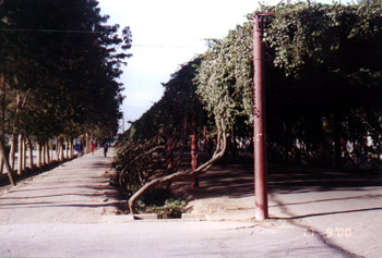 |
Tunnel of grapevine large enough for vehicles in Turpan
|
The access road to the hotel was rather unique. It was covered with grapevine trellises converting the road into a delightful green tunnel big enough for vehicles to pass through. Just opposite the hotel across the vine-covered road there was a café called John's Café, a hangout for many Mat Sallehs. It was a place where one could find cheap western food. So for the next few days I would not have any problems looking for food for my family!
Turpan, an oasis town about 150 km southeast of Urumqi, lies in the Turpan Basin at the southern foot of the Tianshan Mountains. It was an important town on the ancient Silk Road. It is located in a depression, about 80 meters below sea level, the lowest city in China. Because of its low elevation, Turpan has extreme climate - well over 40 Degree C in summer and below freezing in winter.
Turpan is an important agricultural oasis famed for its seedless grapes. It is also rich in historical relics such as the ruined cities of Jiaohe and Gaochang and the Thousand Buddha Caves in the countryside. Therefore Turpan is an important and popular tourist destination in Xinjiang.
Sept 16: Turpan
We left Turpan Hotel at about 9 am and our first destination was Sugong Minaret. But before I boarded the vehicle, I saw one of the rear tyres was a bit deflated. So we quickly drove to a tyre-repair workshop near our hotel. I was surprised that in spite of so many burst tyres in Xinjiang, the mechanic took over an hour to mend this one and with the help of the driver too!
Sugong Minaret or Emin Minaret is only about 2 km from the town. The only attraction was the 37 meter tall minaret in the shape of a cone. It was built in 1778 and constructed entirely with bricks. The bricks were intricately laid to produce various patterns and designs on its wall. It looked elegant and revealed the artistic talents of the Uygur people.
 |
Sugong Minaret
|
From Sugong Minaret we proceeded to Karez Well Museum also near the town. In the Museum there was a model of the Turpan Depression showing the working of the ingenious Karez Well System. And beside the Museum one could take a first hand look of the Karez System in operation.
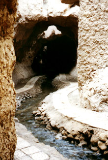 |
Karez Well System
|
Karez Well System is a system of underground water collection and distribution system found mainly in the Turpan Basin. It consists of a series of vertical wells 10 to 20 meters apart connecting underground water channels.
In spring and summer, rainwater and snow melt from the mountains north of Turpan Basin seep into the sand. Due to the sloping topography of the region, the inhabitants dug wells and built underground channels to collect water from the foot of the mountains to the oases. From these wells the inhabitants can extract water not only for irrigating their farms but also for consumption. Because of inclement climate, this underground system is ideal for water conservation; it would minimise loss due to evaporation during summer and prevent freezing during winter.
It is reported that there are more than 1000 of these wells connecting over 5000 kilometers of channels in Turpan area. Though this underground system was reported to have existed during the Han dynasty (200 - 100 B C) the majority of these were constructed during the Qing dynasty (17th Century) and many of these are still being used until today.
Along both sides of the highway to the Flaming Mountains near Turpan, one can actually see igloo-shaped mounds in the desert, which are the heads of these wells.
After a tour of the Karez System location beside the Museum, we proceeded to visit the ruins of Jiaohe, about 12 km west of Turpan town.
The name Jiaohe means the meeting of rivers. As the name implies, the ancient city of Jiaohe was built on a cliff where two rivers converged. The earthen cliff measuring 1650 by 350 meters is 30 meters above the rivers. The city has no walls as the precipitous cliffs act as protective and natural fortification for the city.
 |
Ruins of Jiaohe
|
The construction of the city started as early as in the Han Dynasty (200 BC). It expanded and flourished under subsequent dynasties. However it was destroyed and abandoned during the Mongolian rebellion at the end of the Yuan Dynasty (14th Century).
The construction of the buildings was rather unique. The buildings were basically two-storey high with the ground floor built below the ground. Therefore the first floor and the roof would be constructed first with earth and bricks. The ground would then be dug out to form the living quarters and courtyards.
The identifications of the ruins of the city gates, the streets, temples, residences, official buildings and other structures were posted, but the remains of the ruins on the surface bore very little resemblance of the original structures. However, below the ground the remains of the courtyards, the walls of the living quarters and the wells were comparatively well preserved.
Coming out of the ruined city, we had watermelons for lunch. After that we drove to the Grape Valley.
 |
All the grapes you could eat! |
The Grape Valley is situated in the suburbs of Turpan, 15 km east of the town. The valley is a narrow strip of fertile land 8 km long by ½ km wide lying on the western face of the Flaming Mountains. This is the place which produces the world famous seedless white grapes, accounting for over 90% of seedless grapes cultivated in China. The valley is filled with vine trellised walkways which are covered with bunches of grapes. The valley also produces other fruits such as melons, apricots, apples, pears and peaches.
Along the valley and on slopes of the mountains are drying houses with openings in the walls in which hang strings of grapes drying slowly in a natural process to produce sweet raisins.
We took a walk in the valley but had to pay an entrance fee of 20 yuan each at the visitor's reception centre. Inside the centre there was a walkway covered with grapevine trellises with bunches of grapes hanging and one could take one's pick any amount one could eat. Along both sides of the walkway were stalls selling mostly raisins of various grades, sizes and colours. There were also food stalls selling kebabs and varieties of other local delicacies. We ordered some kebabs and La Mian to supplement our watermelon lunch. On both sides of the walkway one could see grapes hanging and almost touching the ground. It was really tempting and like many other visitors we could not help going out there and help ourselves to more delicious grapes.
| back to page 1 |