

nakedeyeview.com.my 2008

pagenumber
Trekking In Maliau Basin - The Land Of Leeches & Waterfalls
 |
Trekking in Maliau basin – the land of leeches & waterfalls Seven of us explored the jungles of Maliau Basin from 5th to 11th of July. We trekked to Camel Trophy Camp, Ginseng Camp, Agathis Camp, Maliau Falls and a few other places of interest. The treks in rugged wilderness infested with leeches were tough but enjoyable. However, the services provided by the rangers and the maintenance of the camps left much to be desired. |
A. Introduction
Maliau Basin Conservation Area (MBCA), the “Lost World” of Sabah, is located in the southern central part of the State of Sabah. It is a huge bowl of over 390 sq km in area and about 25 km in diameter. Its perimeter is ringed by mountains of steep slopes up to 1,500m in height. The Basin resembles a volcanic caldera but is in fact a sedimentary formation comprised mainly of sandstone and mudstone. Because of its geological formation, the Basin has the highest number of waterfalls in Malaysia.
The whole Basin is a single water catchment and is drained by numerous radiating tributaries of Maliau River, one of which descends into a magnificent seven-tier waterfall called Maliau Falls. There are many other smaller waterfalls throughout the Basin. Maliau River then drains through a gorge out of the Basin in its southeastern part. The water in Maliau River is tea-coloured and acidic, due to tannins leaching out of decaying leaves.
It is reported that only about 25% of the Basin has been explored and in the pristine rainforests there are over 1,800 species of plants, 250 types of birds, 80 kinds of animals and millions of insects, including the countless blood sucking leeches. The leeches survive best in untouched wilderness with a healthy population of wildlife. They need a thriving population of warm-blooded mammals (including intruding human beings) to feed on and they usually wait around trails frequented by wildlife.
Though the Basin was “officially discovered” in 1947, it was only in the 1980s that it formed part of the 10,000 sq km of timber concession given by the State to Yayasan Sabah (Sabah Foundation). Recognizing the uniqueness of the area, Yayasan Sabah designated 390 sq km of the Basin as a Conservation Area for purposes of scientific research and education. In 1997 the Basin was gazetted as a Class 1 Protection Forest Reserve by the State Government. At the same time the Reserve was extended to include 198 sq km of forested land outside the Basin. The whole area of 588 sq km is now known as Maliau Basin Conservation Area. Maliau Basin received further protection in 1999 when it was gazetted as a cultural heritage site.
The Conservation Area is presently managed by the Maliau Basin Management Committee with representatives from Yayasan Sabah, government departments, education institutions and NGOs. Maliau Basin is ideal for jungle trekking, wilderness adventures, photography and recreation.
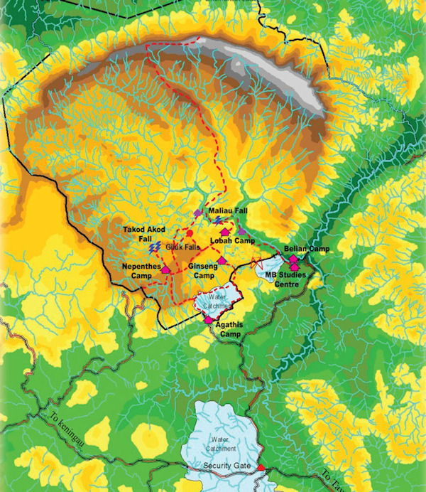
Map of Maliau Basin Conservation Area
B. Itinerary
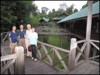
The tour of Maliau basin was organized by Kenny Lim who dealt directly with the management of Maliau Basin Conservation Area in Tawau without going through any tour agent. There were seven trekkers in the group which included three ladies.
 |
The brief itinerary is as follows: Day I (06/07) – Flight from KLIA to Tawau. By car to Studies Centre in Maliau Basin. Overnight in Studies Centre. Day 2 (07/07) – By car to Agathis Camp and trekked to Camel Trophy Camp. Day 3 (08/07) – Trekked to Giluk Waterfall and Ginseng Camp. Day 4 (09/07) – Trekked to Maliau Waterfalls and back to Ginseng Camp. Day 5 (10/07) – Trekked to Agathis Camp. Day 6 (11/07) – Trekked to see the giant Agathis tree and returned to Tawau by car. Day 7 (12/07) – Flight from Tawau to KLIA. <-- The Magnificent Seven |
C. Trekking in Maliau Basin
1. Journey from Tawau to Studies Centre (06/07)
We arrived at Tawau Airport before noon on 06/07. We were picked up by driver Jackson, and driven to Tawau in a 4WD Land Cruiser, fitted with large wheels, to the office of MBCA to settle the transportation cost and to obtain a permit for the visit. After lunch in town we left for MBCA. The first part of the journey (about 80km) along the paved highway from Tawau to Keningau/Kota Kinabalu was smooth, winding through green countryside with huge oil palm plantations. However, after we reached a giant roundabout, the road, flanked by secondary rainforests, was unpaved and bumpy, and after nearly three hours on this gravel road (over 90km) we finally reached the Security Gate of the MBCA and the Shell Maliau Basin Reception And Information Building. As very little information was available there, we proceeded to the Maliau Basin Studies Centre after registration at the Security Gate.
 |
 |
Gravel highway to Security Gate |
Shell Maliau Basin Reception & Info Building |
The Studies Centre is located 27km from the Security Gate and we took slightly less an hour travelling along the narrow earth track to reach there. The Studies Centre is quite a huge complex, consisting of hostel, rest house, conference room, laboratory and facilities for students and researchers.
We occupied three fan-rooms with hot water shower and coffee making facility; quite unexpected in the fringe of the tropical rainforests. We checked in after 5pm and after a rest and a refreshing hot shower we had a sumptuous buffet dinner at 7pm.
After dinner we settled the account of our trip at the reception and retired early in anticipation of a long and tough journey the next day to Camel Trophy Camp.
 |
 |
Access to accommodation blocks in Studies Centre ........Front view of Studies Centre

The lake in front of Studies Centre
We woke up early the next morning (07/07) as we wanted to visit Sky Bridge before departing for Agathis Camp. After a quick breakfast, we walked to Sky Bridge, located a short distance from Studies Centre. Sky Bridge is a long suspension walkway bridge linking eight trees just inside the Conservation Area on the banks of Maliau River.
 |
|
The Sky Bridge