nakedeyeview.com.my 2008


pagenumber
The Arduous Lombok Trek
(11th – 14th July 2014)
Itinerary
Day 1 – 11 July: Lombok Airport to Senggigi.
Day 2 – 12 July: Senggigi to Sembalun & Crater Rim.
Day3 – 13 July: Crater Rim to Rinjani Summit, Segara Anak Lake & Senaru Crater Rim.
Day 4 – 14 July: Senaru Crater Rim to Senaru Village & Senggigi.
Map of Lombok Island
A. Introduction
Mt. Rinjani, located in the north of Lombok Island, is 3,726 meters above sea level and the second highest volcano in Indonesia. It has a huge crater at the top which contains a beautiful lake called Danua Segara Anak (Child of the sea lake) and a small volcanic cone called Mount Baru Jari, which was formed a couple of hundred years ago.
The whole of the Rinjani area was gazetted as a national park in 1997. In 2004 Mt Rinjani won the World Legacy Award and the volcano is recognized internationally as an important eco tourism destination. It is one of the most famous trekking destinations in Southeast Asia, attracting thousands of trekkers annually.
Three Malaysians, Kenny Lim, K C Cheah and I participated in this expedition which was organized by Kenny.
B. The Trek
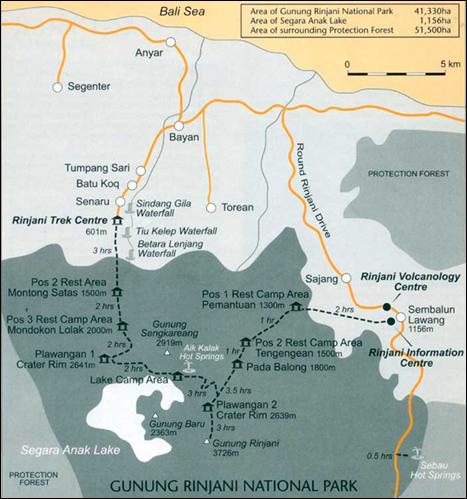
Route Map
Day 1 (11th July) – In Senggigi
We flew to Mataram, the capital city of Lombok by Air Asia on 11th July. We were met at the airport by a representative from Lombok Network Holidays, the tour company which organized our Lombok trek.
We were transferred by a 4WD vehicle to Senggigi on the east coast of the island. The journey took about half an hour. We put up in a hotel for a night.
Day 2 (12th July) – Senggigi to Sembalun and Crater Rim
We woke up before 5am for our breakfast. We were picked up and transferred to the starting trek point at Sembalun Village. The journey took about three hours. We registered at the Ranjani Information Centre in Sembalun Lawang where we also met up with our Guide (Bulloh) and three porters who carried the tents, sleeping bags, cooking utensils, food etc.
We started our trek from here and went through open grassland to Pos 1 Pemantauan (1,300m). We rested here and enjoyed the summit views of Mt. Rinjani.

Gentle trail to Pos 1 with Mt. Rinjani in the background
After a short rest, we continued our trek and after about an hour’s walk we reached Pos 2 Tengengean (1,500m). We proceeded and reached Pos 3 Pada Batong (1,800m) in about 1.5 hours and stopped here for our lunch.
After lunch, we continued our trek up to Sembalun Crater Rim (2,639m). This was the toughest trek of the day and after about 3.5 hours we reached the campsite of Plawangan II just before 6pm.

Lake in Sembalun Crater Rim

Our guide, Bulloh and the porters set up the tents for the night and prepared dinner which was served to us in our tents.
We retired in our tents immediately after dinner as the sun was down and the campsite was in complete darkness before 7pm. Also we had to get up around 2.30am the next morning for the trek to the summit.
It was drizzling all night long and coupled with lying on a thin layer of mattress (about one inch thick) without a pillow, my back ached and I did not get a good wink of sleep the whole night.
We had to wake up early the next morning to make sure we arrive at the top Mt. Ringani before sunrise, not only to experience the spectacular sight at the summit but also to have the best chance of getting clear views.
Go to Home Pg Pg 1 go to Pg 2